Add a Curriculum Bundle to Your Account!
Please select a bundle.


The Pack contains associated resources for the learning experience, typically in the form of articles and videos. There is a teacher Pack (with only teacher information) and a student Pack (which contains only student information). As a teacher, you can toggle between both to see everything.
Here are the teacher pack items for Central America and the Caribbean: Geographic Passport:


Overview In this experience, students examine the physical geography of Central America and the Caribbean by labeling maps and identifying major countries and geographic features. They read about terrain, climate and ecosystems, natural hazards, and natural resources in each region. Then they research one country or territory and create a travel geography poster highlighting its most significant geographic features. Finally, students explain how geography influences how people live in Central America and the Caribbean. Objectives:
Central America and the Caribbean are two neighboring regions that connect North America and South America and include a wide variety of landscapes. Central America is a narrow land region between Mexico and South America, while the Caribbean includes hundreds of islands surrounded by the Caribbean Sea and nearby Atlantic waters.
The geography of these regions includes mountains, volcanoes, tropical forests, coastlines, and islands. Their location and physical features influence climate, settlement, transportation, natural hazards, and how people use the land.
In this experience, you will explore the physical and human geography of Central America and the Caribbean.
Objectives:
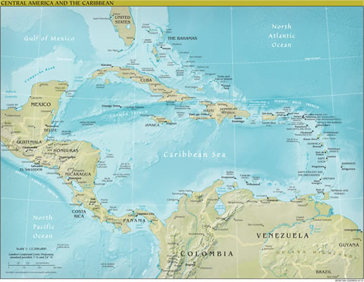
Central America and the Caribbean Islands
In the table, write a fact you already know about Central America. Then write something you would like to know.

When everyone is ready to continue, unlock the next scene.


