Add a Curriculum Bundle to Your Account!
Please select a bundle.



The Pack contains associated resources for the learning experience, typically in the form of articles and videos. There is a teacher Pack (with only teacher information) and a student Pack (which contains only student information). As a teacher, you can toggle between both to see everything.
Here are the teacher pack items for China and Its Neighbors: Geographic Passport:

Overview: In this experience, students examine China’s physical geography and investigate how landforms, climate, rivers, and elevation relate to patterns of human settlement. They use maps and Exploration World to compare physical and human geography, then analyze how these relationships help explain population patterns across China. Finally, students research Taiwan or Mongolia and compare how geography influences where and how people live in neighboring places. Objectives:
People do not live evenly across Earth. Some places contain large cities and dense populations, while other areas have few permanent settlements. Physical features such as mountains, deserts, rivers, plains, and climate can help explain some of these patterns.
China is especially useful for studying this relationship because it contains enormous geographic differences. High mountains and plateaus rise in the west, deserts stretch across parts of the north and northwest, major rivers cross the country, and broad plains cover much of the east. These environments create different opportunities and challenges for settlement, farming, transportation, and other human activities.
Physical geography does not determine exactly where people live. Technology, history, economic opportunities, and human decisions also matter. However, comparing physical and human geography can reveal important patterns.
In this experience, you will examine China’s physical geography, investigate how terrain and climate relate to population patterns, and compare China with Taiwan and Mongolia.
Objectives:
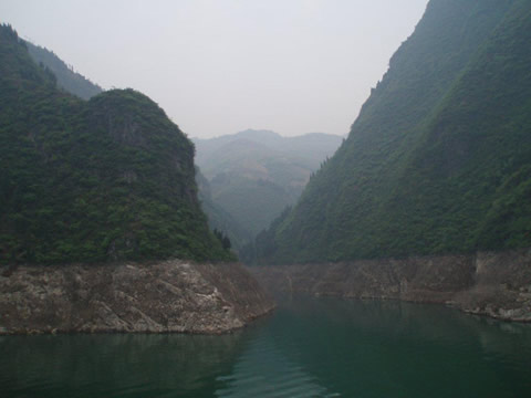
Dragon Gate Gorge on the Daning River, a tributary of the Yangtze River
Before examining detailed maps, make a prediction: Consider the image of the Dragon Gate Gorge above. How might landforms such as this affect where and how people live in China? Explain one relationship you predict you might find.
After students respond, invite several students to share their predictions and explain what geographic feature influenced their thinking. Use the discussion to establish that students are making hypotheses they will test with evidence later in the experience. Students may predict that flatter land, access to rivers, or milder climates support larger populations, while mountains, high elevations, or deserts may have fewer people. Do not confirm these predictions yet. Reinforce that physical geography can influence settlement without completely determining where people live. Possible follow-up questions include:
When everyone is ready to continue, unlock the next scene.


